

Research project Botswana
PhD project Kalahari Wildlife Assessment
In Botswana's Kalahari, never has the need for effective and efficient wildlife population assessment and monitoring been so great. Wildlife utilization has long been the primary land use over vast Wildlife Management Areas (WMAs) that lay outside of strictly protected areas and constitute the majority of conservation land. In 2014 a hunting ban was instated countrywide, due in part to concerns over wildlife populations in continuing decline. However, the information upon which such decisions are based is limited; the areas to be surveyed are vast, and Government budgets for doing so are modest. Added to this, local people that are entrusted to manage and benefit from their natural resources have not had adequate input into wildlife management.
Using light aircraft to count wildlife has been the standard procedure in Africa for the last 60 years. Although expensive, airplanes are efficient at covering huge areas of relatively open country. Unfortunately, spotting animals from an airplane is plagued by visibility biases. Proper design can control some of the sources of bias; others cannot be remedied. Together these biases systematically result in undercounts for a limited number of large-bodied animals of open country, typically plains antelopes. Beyond those, what is happening to the multitude of species that are too small, cryptic, nocturnal or otherwise invisible to observers in an airplane, is left to educated guesswork. Wildlife decision-making throughout the Kalahari and most of Botswana has been based almost entirely on aerial survey data.
Using light aircraft to count wildlife has been the standard procedure in Africa for the last 60 years. Although expensive, airplanes are efficient at covering huge areas of relatively open country. Unfortunately, spotting animals from an airplane is plagued by visibility biases. Proper design can control some of the sources of bias; others cannot be remedied. Together these biases systematically result in undercounts for a limited number of large-bodied animals of open country, typically plains antelopes. Beyond those, what is happening to the multitude of species that are too small, cryptic, nocturnal or otherwise invisible to observers in an airplane, is left to educated guesswork. Wildlife decision-making throughout the Kalahari and most of Botswana has been based almost entirely on aerial survey data.
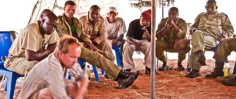
Photo: Julia Burger
A practical, cost-effective method of surveying wildlife that can capture data on all species simultaneously while involving local people could transform capacity to monitor, manage, and conserve wildlife throughout the Kalahari region.
Comanis has been a major supporter of a project intended to address these challenges. With background familiarity with aerial surveys and tracking from the snowy regions of Western Canada, PhD student Derek Keeping focused on the Kgalagadi District in southern Botswana to begin investigating track-based alternatives for wildlife population assessment.
The Kalahari has two advantages that most other environments have not. Firstly, the ground is an ocean of sand that continually records the history of all things that walk, regardless of season. Secondly, by no coincidence of the first fact, the people that inhabit this environment tend to be exceptional trackers. Humankind's hunting and gathering history is still fresh in the Kalahari, and this project collaborated with young men that spent much of their lives honing their tracking skills.
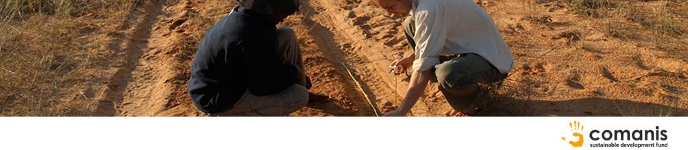
Together the research team covered long stretches of sand roads crisscrossing Kgalagadi District, whilst scrutinizing and recording all fresh animal crossings from perched "tracker seats" on the front of a 4x4 vehicle. It did not take long to discover that a single night's animal activity produced track encounter rates that were orders of magnitude greater than the numbers of animals that could be observed directly. For example, it takes about 600 kilometres of driving at night in order to see an aardvark in the Kalahari, while one need only observe tracks for 4 kilometres on average before finding an aardvark spoor from the previous evening!
Comanis has been a major supporter of a project intended to address these challenges. With background familiarity with aerial surveys and tracking from the snowy regions of Western Canada, PhD student Derek Keeping focused on the Kgalagadi District in southern Botswana to begin investigating track-based alternatives for wildlife population assessment.
The Kalahari has two advantages that most other environments have not. Firstly, the ground is an ocean of sand that continually records the history of all things that walk, regardless of season. Secondly, by no coincidence of the first fact, the people that inhabit this environment tend to be exceptional trackers. Humankind's hunting and gathering history is still fresh in the Kalahari, and this project collaborated with young men that spent much of their lives honing their tracking skills.
Together the research team covered long stretches of sand roads crisscrossing Kgalagadi District, whilst scrutinizing and recording all fresh animal crossings from perched "tracker seats" on the front of a 4x4 vehicle. It did not take long to discover that a single night's animal activity produced track encounter rates that were orders of magnitude greater than the numbers of animals that could be observed directly. For example, it takes about 600 kilometres of driving at night in order to see an aardvark in the Kalahari, while one need only observe tracks for 4 kilometres on average before finding an aardvark spoor from the previous evening!
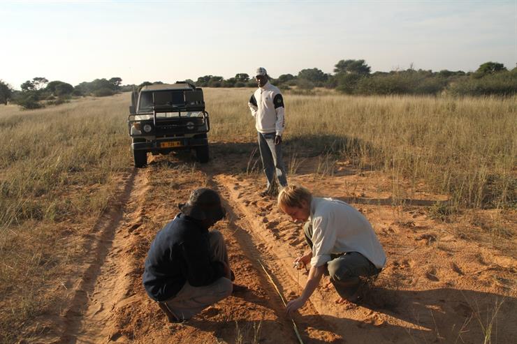
Photo: Corinne Itten
The central challenge faced by the project was how to convert track counts into the density of animals on the landscape, i.e. an estimate of the number of animals occupying a specific area. The problem seems intuitively daunting, and is one of the reasons wildlife managers continue to dismiss track counts in favour of direct counts like aerial surveys. Luckily, a theoretical foundation was re-discovered in an obscure Russian literature. It described an eloquently simple relationship between the density of animals inhabiting an area, counts of their tracks, and the average distance that those animals move on a daily basis (day range).
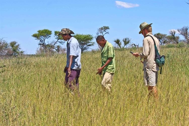
The key unknown was day range, and it is not easy to estimate the distance that animals walk in 24 hours. Fortunately, there is a coarse relationship between the body mass of animals and their day range. Larger animals tend to walk farther in a day than smaller animals. To test this relationship the team needed very accurate estimates of Kalahari species' day ranges - more accurate than what can typically be estimated through deployment of radio of GPS collars on animals. So instead they began tracing the actual paths that animals walked over 24 hrs, by following their tracks both on foot and from horseback.
These accurate samples of animal movements for a subset of species were used to predict day ranges for the remaining Kalahari species. Day range estimates were then applied to the track counts to generate the first comprehensive population estimates for the Kalahari wildlife community. The team showed how simple track counts could be used to estimate animal densities for everything inclusively from the largest mammal down to small reptiles. This includes a majority of species that are undetectable using other methods like aerial surveys.
This is the first project anywhere in the world to successfully assess population density for an entire wildlife community based on their tracks. It has demonstrated an inexpensive and practical technique for counting wildlife in terrestrial environments that are underlain with suitable substrates such as sand or snow. Botswana's Kalahari is perhaps better-suited than any other region. Firstly, sand covers 80% of surface of the country, and secondly, there is a latent force of skilled and enthusiastic trackers residing in remote area settlements who have few alternative employment prospects. It makes sense for their advanced tracking skills to be put to use in wildlife conservation.
This work has caught the attention of wildlife managers and conservationists in several regions of the world. Botswana's Department of Wildlife and National Parks have expressed interest in training biologists on track-based survey methods and collaborating with trackers from remote Kalahari villages.
Comanis continues to support the application of these techniques to enhance wildlife conservation in the Kalahari.
The first results of this project have been published and are available for download:
Keeping2014AnimConserv.pdf (667620, PDF, neues Fenster) Publication by Derek Keeping and sponsored by Comanis Foundation
KeepingPelletier2014PLoSOne.pdf (1714993, PDF, neues Fenster) Publication by Derek Keeping and sponsored by Comanis Foundation